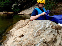
During a pleasure float on a spring Sunday in 2011 archaeologist, Chris Espenshade, noticed a large pock-marked rock in the river that reminded him of some petroglyphs his organization recently identified on the Hiwassee River near Cherokee, North Carolina. The type of markings are known as cupules and are considered the oldest form of rock art known.
Chris returned to the river the following Wednesday with his son, Andrew, as well as me, Dale Swanson. The Dan River Company provided our shuttle to their private access just downstream of the Highway 89 bridge - a huge convenience. After launching Andrew took off like a rocket apparently bored by two old guys talking and examining every rock along the riverbank for unnatural markings.
 About a mile downstream, after passing "Snake Island", we approached the mouth of North Double Creek marking the upstream border of George's Bottom. A low rock in the middle of the stream clearly had Chris' attention as we got closer. I experienced a funny 'Aha' moment when the pock-faced rock came into focus and exclaimed, "That's the Indian Rock!" Of course, I had noticed it years ago and was familiar with the local speculation about the purpose of the little cup-shaped divots in it. Grinding corn or nuts or inks were the most common suggestions - none of which had ever made sense to me.
 Chris explained that over the past year his company, New South Associates, had been contracted to survey the Hiwassee River in Cherokee, NC. That project had revealed rock art in the form of cupules on rocks just upstream of each of three Native American fish traps or weirs in the study area. The Dan River "Indian Rock" at North Double Creek appears to be similar in design and location to those already documented artifacts.
 The layout of area around the Indian Rock helps to create a picture of pre-colonial life along the Dan River. George's Bottom, where the rock is located, would have been a bustling village. It's 40 acres are bounded almost entirely by the running waters of the Dan River, North Double Creek and South Double Creek. A truly ideal location for a village. The farmland that occupies that space today is rumored to be rich with arrowheads and other stone tools.
Sitting on the rock and looking downstream you can imagine the activity of the area. Two large gravel bars in the riverbed - a major frustration for recreational boaters in August when the water is low - would almost certainly have been arranged into fish traps. This setting provides a cultural environment very similar to the area studied on the Hiwassee River. I could imagine children playing in the river and possibly sitting on that same rock. Could the 45 to 50 cupules on that rock been carved by generations of bored children?
Experts remain puzzled by the specific purpose of these 'cupules' which are found throughout the world. It seems unlikely that the cups were useful in any utilitarian way - they are simply too small for grinding quantities of grains or nuts. And so researchers fall back into the standard "don't know" response - "some type of ritual."
So the next time you float the Dan River from Highway 89 to Moore's Springs Campground or beyond - take a moment to drink in a little historical reverie with our long departed neighbors. It is humbling and will enrich your experience of our world.


